Quantcast
Channel: Explained Archives - Sometimes Interesting
Viewing all 97 articles
Browse latest View live

The Mahencha Apartments of Gary, Indiana

$
0
0
Sometimes Interesting has teamed up with the Idiot Photographer to bring the reader a unique insight to the history of Gary, Indiana. Over the coming weeks we will feature various structures and tell their history. Today we detail the life of the 85 year-old building known at various times as The Mahencha, Mahencia, and Hatcher […]

The Abandoned Sheraton Hotel of Gary, Indiana

$
0
0
Not every abandoned building in Gary, Indiana has an enchanting history. Several epitomize the failed attempts to revitalize, and instead showcase the city’s history of financial failures. The abandoned Sheraton Hotel is one such example. Originally opened in 1968 as a Holiday Inn, the building would close only four years later. It was later renovated […]

Emerson School of Gary, Indiana

$
0
0
There is no shortage of abandoned schools in Gary, Indiana; the declining population over the decades has left the school district scrambling to close and reorganize schools. Annually decreasing budgets complicate attempts to maintain or repair the crumbling structures. The Emerson School was Gary’s first high school, built in 1908. It was the proud work […]

City United Methodist Church of Gary, Indiana

$
0
0
Perhaps one of the most iconic abandoned structures in Gary, City United Methodist Church was once the pride of the community. Built in 1925, the classic Gothic edifice was the result of an ambitious priest backed by U.S. Steel dollars. But the huge structure would burden the church with enormous maintenance costs for decades, and […]

The Palace Theater of Gary, Indiana

$
0
0
Another icon of Gary is the majestic Palace Theater, opened in 1925. One of the finer examples of Atmospheric theater design, it was the crown jewel of a northwest Indiana theater conglomerate. The theater would be the longest-running in Gary, and served residents for nearly 50 years before succumbing to crime and financial difficulties. It […]

The Gary-Alerding Settlement House

$
0
0
When Gary, Indiana was founded by U.S. Steel in 1906, the steelworker was often not American. However the history of immigrants in Gary is often overlooked by the frequent black–white dichotomy in the narrative of the city’s more recent history. Perhaps not as well known is the history of Gary’s foreign workers and the assimilation […]

The Ambassador Apartments of Gary, Indiana

$
0
0
There certainly isn’t a dearth of classic early twentieth century architecture around Gary, Indiana. Another fine example is that of the Ambassador Apartments at 574 Monroe Street. Finished in 1928, the luxurious building featured views and amenities no other place in town could match. Initially it would cater to Gary’s high society, but decades of […]

The Horace Mann School

$
0
0
The Horace Mann School of Gary, Indiana is on the short list of American high schools that have graduated more than 75 classes of students. A creation of innovative educator William Wirt, the unique school took seven years to build and was finished in 1928. The campus set a new standard for the area’s public […]

Abandoned: St. Mary’s Mercy Hospital

$
0
0
In the final installment of the Gary series, we take a look at the skeleton of a healthcare organization founded over one hundred years ago. Originally established in 1908, St. Mary’s Mercy Hospital would see multiple additions and renovations over the years while it expanded to accommodate the city’s growing number of residents. But when […]

Count Bagno’s City of Toys: Consonno, Italy

$
0
0
When Count Mario Bagno purchased a large amount of land in the remote northern hills of Italy fifty years ago, he envisioned building a Las Vegas-style adult playground with bars, casinos, and dance clubs. The resort town of Consonno, nestled in the hills of Brianza not far from Lecco, was intended to be the premiere […]

Largest Ship Graveyard in the World: Nouadhibou, Mauritania

$
0
0
Extending from the west coast of Africa is Ras Nouadhibou, a small peninsula shared by Mauritania and Western Sahara. The east side of the peninsula belongs to Mauritania and is home to Nouadhibou, a city of nearly 100,000 residents and the second-largest settlement in the country. The region’s economic capital, Nouadhibou holds less illustrious titles […]

Turkmenistan’s Door to Hell

$
0
0
Turkmenistan is seventy percent desert – the Karakum Desert, to be exact. The nation is divided into five provinces, the second largest being the Ahal Welayat which occupies the south-central portion of the country. Ahal is almost entirely desert and contains just fourteen percent of the country’s population, but it is also rich in natural […]

Texas City Disaster: Deadliest Industrial Accident in U.S. History

$
0
0
Across the bay from Galveston in Texas is Texas City, a busy port with convenient access to Houston and the Gulf of Mexico. In addition to shipping, the city plays an important role in the production and refining of petroleum products. As a port with deep water access to the coast, Texas City hosts international […]

Hottest Inhabited Place on Earth: Dallol, Ethiopia

$
0
0
The Afar Region of Africa, named for the people who call it home, encompasses Djibouti, Eritrea, and the northeast corner of Ethiopia. A notable trait of the Afar Triangle is the Danakil Depression, the lowest point in Africa. The territory is one of the hottest on the planet, and features everything from earthquakes and volcanoes […]

Rescuing The Citarum River

$
0
0
Forty miles east of Jakarta, a river over 186 miles (300km) long winds across the island of Java. For thousands of years the Citarum River has been an important resource for the Indonesian people. Today it continues to support fishing, agriculture, electricity generation, and sewerage for nearly 30 million residents. When Indonesia experienced a manufacturing […]

Casualties of Copper: The Berkeley Pit, Montana

$
0
0
Tales of gold rushes and silver booms are often recounted from a nostalgic perspective, driven by tall tales of adventures into the lawless Wild West. Perhaps less sentimental is the story of copper, a metal with less value but more significance to the growth of infrastructure. Copper was a major component of industrialization and essential […]

Concrete Arrows and the U.S. Airmail Beacon System

$
0
0

airmail-beacon-concrete-arrow

Scattered across the United States is a network of mysterious concrete arrows. They are often found in remote locations or areas difficult to access. Some will be accompanied by a small shack, a few have a metal tower affixed to their base. Many are in good condition while others have succumbed to nature. The shape and direction of the arrows vary, but it is clear they served the same purpose.

The purpose was important: helping early pilots navigate U.S. transcontinental flights at night.

In a era before radar, pilots used ground-based landmarks for guidance. This solution worked for flight during the day, but grounded pilots at night. Before long, a system of beacons was established across the United States to guide airmail pilots around-the-clock. When radar and radio communications made the beacons obsolete years later, most were torn down and abandoned.

*

airmail-beacon-route-1924

Early Airmail Beacon Route Map circa 1924. (does not include later spur routes)

*

History

In the mid-19th century the Wild West was largely unexplored. There was no infrastructure and very little law governing the land. Understandably, coast-to-coast message delivery was nonexistent. It was not until a gold discovery in 1848 that California became the destination for tens of thousands from the east. The trip across the country was arduous, dangerous, and could take anywhere from three to six weeks.

airmail-beacon-Omaha1920sBy 1860, the Pony Express revolutionized transcontinental mail by offering delivery in about ten days. Nearly unheard-of at the time, this was faster than the more volatile southern route favored by others. Knowledgeable frontiersmen would race across the country on horseback, covering vast distances in shorter times.

While the Pony Express was significant in that it proved the northern/central mail route was possible, it was inefficient compared to stagecoach lines. Higher costs and poor economies of scale would see the Pony Express fail to win the mail contract beyond its first year of operation.

A year later, the threat of civil war descended upon the country and resources were diverted to the conflict. When the transcontinental telegraph line was completed in 1861, it immediately rendered the Pony Express obsolete.

In the late 19th century, reliability of mail delivery improved – but not its speed. It was not until the invention of the airplane that intercontinental mail delivery witnessed its next major breakthrough.

*

Early Aviation & Airmail

The Wright brothers made the first flight in 1903, and it wasn’t long before pilots adopted air transport for mail delivery. By 1911, Fred Wiseman had conducted an unofficial airmail flight carrying three letters from Petaluma to Santa Rosa, California.

The next day, a large exhibition orchestrated by Sir Walter George Windham in British India made the first official airmail flight. Windham used the event to generate publicity and raise money for charity. His pilot, Henri Pequet, would fly just over 8 miles from Allahabad to Naini to deliver 6,500 letters.

(Click thumbnails to enlarge)

airmail-service-1926 airmail-boise-idaho airmail-beacon-airfield-Nebraska1920s

(L to R: early airmail flight, Boise Airmail Station, Intermediate Field with tower in Nebraska)

It wasn’t until three years later the range capability of mail delivery aircraft was really tested. In July of 1914, French pilot Maurice Guillaux carried Australian mail 584 miles from Melbourne to Sydney – at the time the longest such flight in the world.

By 1918 the east coast of the United States had limited airmail service. Two years later, a North American transcontinental airmail route was finally established. On August 20th, 1920 – sixty years after the Pony Express – rapid delivery made a return to the U.S.

airmail-vintage-ad

1926-vintage newspaper advertisement for airmail service

*

Beacon Tower System

Aircraft of the era lacked the advanced electronics for navigation during night flights or through inclement weather. Long before the advent of radio guidance or Instrument Flight Rules (IFR), pilots were limited to visual guidance, using landmarks to chart the route.

Flying at night was out of the question; bad weather and limited flight times meant delivery was limited and still spotty in frequency. The service was indeed faster, but it lacked flexibility and reliability of operations.

By 1924 the Postal Service developed a solution that was effective, if not elegant. A system of ground-based navigation beacons extending from New York to San Francisco would help pilots fly across the country at night and ultimately be the world’s first such system.

The early iterations of the system used approximately 1,500 airmail beacons, each constructed roughly between 3 and 5 miles apart. The beacons featured a 50-foot tower with rotating lights placed on top of concrete foundations in the shape of giant arrows measuring between 50 and 70 feet long. To increase visibility of the concrete arrows, they were painted bright yellow.

airmail-beacon-design airmail-beacon-graphic airmail-beacon-example

(L to R: beacon in concept, illustration, and execution)

The first towers contained acetylene-gas powered lights which were fed by fuel stored in a shed at the base. At the top of the towers, a rotating beacon with 5,000 candlepower and would flash every ten seconds. In clear weather the beacon lights could be seen for 10 miles (16 km). Below the main white beacon, a secondary set of red and green lights would flash a Morse Code letter to identify the beacon to pilots.

To accommodate for emergencies, intermediate landing fields were established every 25 miles along the route. The fields were constructed with rotating incandescent electric lights mounted on 50-foot towers set to sweep six times per minute. These less-common emergency field beacons were visible up to 75 miles away.

The program was an immediate success and continued to expand throughout its operational life. By the end of the first year the airmail service had 18 terminal airfields, 89 emergency airfields, and more than 500 beacon lights in operation.

(Click thumbnails to enlarge)

airmail-envelope  airmail-beacon-stamp  early-US-airmail

*

Rapid Growth Until Obsolete

airmail-beacon-62The program quickly became too large for the Post Office to effectively control. In 1926 management of the beacon system was turned over to the Department of Commerce, which continued expansion or the airmail beacon system until 1929.

As technology improved, so did the towers. Later versions on spur routes were built 10 miles apart and equipped with stronger beacon lights – up to one million candlepower – making them reportedly visible up to 40 miles in clear weather.

But by the 1930s, navigation and radio technology had improved to allow flight without land-based visual guidance. The Low Frequency Radio Range (LFRR) system began to replace older visual-based systems.

The airmail beacon program would continue to operate full-scale until 1933, when technology advancements and the higher cost of operation during the Great Depression – finally rendered it obsolete.

After the program was de-funded, various beacons would continue to operate in limited capacities into the 1940s. At that time, the Department of Commerce decommissioned and disassembled the towers for their steel, a resource in short supply and desperately needed to support the war effort.

The last airway beacon was officially shut down in 1973, although the Montana Department of Transportation Aeronautics Division reportedly continues to operate around 19 updated beacons in the mountains of Western Montana.

(Click thumbnails to enlarge)

airmail-beacon-hudspeth2 airmail-beacon-9 airmail-concrete-arrow-6

*

Today

Ninety years later, most of the towers have been dismantled. Many of the sites are long gone, victims of war, infrastructure growth, and aggressive private developers. During World War II, numerous concrete arrows were destroyed as well – so as to not help enemy pilots visually navigate the country.

Still, hundreds of the arrows remain. But today they lack the bright yellow paint, and the cracks in the concrete worsen with each winter freeze. Arrows on top of mountains are safe for now, but several along the highways have already been lost to redevelopment.

airmail-beacon-8

*

Mapping

For the explorers out there, Sometimes Interesting has compiled a list with map links to locations with visible remains from the original airmail beacon system. This list is not meant to be comprehensive, but it does include many of the locations still visible today:

—–

• A concrete arrow is all that is left of Beacon 68 just west of Albuquerque, New Mexico.

• The faint outline of a concrete arrow and generator shack is still visible in Battle Mountain, Nevada (beacon number unknown).

airmail-beacon-1930s• A concrete arrow just off Interstate 80 about 25 miles southeast of Boise, Idaho points toward the city (beacon number unknown).

• In the wilderness outside of Cheyenne, Wyoming, the remote concrete arrow of Beacon 38 sits undisturbed.

• The faint remains of a concrete arrow can be seen in the defunct municipal airfield in Columbus, New Mexico (beacon number unknown).

• The concrete arrow of Beacon 33 is still visible in Cottage Grove, Minnesota. It is even visible in street view!

• The concrete arrow and generator shed at Delaware Springs Intermediate Field are still visible, deep in remote Texas. Read more about Delaware Springs Field here.

• About 20 miles northeast of Ellensburg, WA, the foundation remains of a beacon can still be seen (beacon number unknown).

• Just outside of Fernley, Nevada sits a lone beacon tower missing the concrete arrow and generator shed (beacon number unknown).

• A concrete arrow is visible off Old Highway 40 near Golconda, Nevada (beacon number unknown).

• The generator shed is all that’s left of Beacon 61 in the mountains of Grants, New Mexico. The tower and concrete arrow may be gone, but you can still see “61″ on the roof of the shed.

• The concrete arrow of Beacon 59 sits right off US-80 in Grantsville, Utah, southwest of the Great Salt Lake.

airmail-beacon-hudspeth

Concrete arrow barely visible at Hudspeth Intermediate Field

• About 55 miles east of El Paso in the middle of nowhere, Texas, the concrete arrow of Hudspeth Intermediate Field barely pokes out of the brush (pictured above). Hudspeth was constructed in the 1930s by the Department of Commerce for emergency use by airlines, but hasn’t been used in half a century.

• The concrete arrow with twin tails from Beacon 61A can be seen just off the Lincoln Highway in Lake Point, Utah. (pictured below, courtesy BonnevilleMariner.com)

labeled-arrow

• Faint remnants of a concrete arrow in Locomotive Springs, Utah (beacon number unknown).

• In Lovelock, Nevada, another concrete arrow can be seen (beacon number unknown).

• Here’s a concrete arrow off a dirt road in Meacham, Oregon (beacon number unknown).

• The Aviation Heritage Museum of Milan, NM has Beacon 62 (originally located in Bonita Canyon) restored to its original 1930s appearance, complete with painted tower and corresponding generator shack (pictured below).

airmail-beacon-NMAHM

The Aviation Heritage Museum of Milan, New Mexico has restored this airway beacon

• Up on Beacon Hill Road in the Moapa Valley region of Nevada, a concrete arrow is still visible (beacon number unknown).

• The concrete arrow of the former MX1095 Beacon can be seen just east of the airport in Montague, California.

• Here is a right-angle concrete arrow from Beacon 50 visible in Montello, Nevada.

• The concrete arrow from Salt Flat Intermediate Field is barely visible in lonely Salt Flat, Texas. This emergency landing field was another product of the Department of Commerce in the 1930s. This page has more detail on the now-defunct Salt Flat Intermediate Field.

• Two miles northwest of Seama, New Mexico, the concrete arrow of Beacon 64 sits behind Flower Mountain, not far from Interstate 40.

• A concrete arrow sits in good condition at Shelbyville Municipal Airport about 25 miles southeast of Indianapolis in Indiana (beacon number unknown).

airmail-beacon-37A-BloomingtonOverlook• Another concrete arrow – this one from Beacon 37B – can be seen on the south edge of the Shinob Kibe Mesa in Utah.

• The concrete arrow from Beacon 37A is visible from the Bloomington Overlook location in St. George, Utah. (pictured at right)

•  A concrete arrow is all that’s left of Beacon 37C at the Quail Creek Reservoir in Utah between Hurricane and St. George.

• The concrete arrow by Strevell Road near the Idaho/Utah border is clearly visible along with the foundations of other facilities, now gone (beacon number unknown).

• Beacon 14A is still overlooking US-80 in the Tahoe National Forest in California. The concrete arrow is gone, but the tower remains. A newer building has replaced the generator shed next to the tower.

• Just outside the Toiyabe National Forest in Reno, a concrete arrow is barely visible and in poor condition (beacon number unknown).

• Little other than the tower’s foundation of Beacon 5 is still visible in Vacaville, California.

• The well-preserved tower of airway Beacon 32 is still in use at Winnemucca Municipal Airport in northern Nevada. You can even see this pristine example in street view. (No concrete arrow or generator shed)

• In Woods Cross, Utah, there is a concrete arrow northeast of the Salt Lake City Airport (beacon number unknown).

*

air-travel-1929-original

Air Traveler’s Map, 1929

“Illustrated Map of the Route of Transcontinental Air Transport,” Rand McNally, 1929. Courtesy David Rumsey Map Collection.

Click thumbnail to view full-size (warning: large file)

*

For a more robust map of reported beacon locations, this user-created Google map has quite a few in the west. This Google document also has assimilated numerous beacon locations nationwide. A listing of beacons can be seen here, although not all have been “found.”

Do you know of another airway beacon or concrete arrow not listed here but still visible? Contact us with the coordinates and we’ll update the list!

airway_beacons_map_clip

**


Abandoned Industrial Icon: Armour Meat Packing Plant

$
0
0

armour-aerial3

The Armour & Company meat packing plant in National City, Illinois is a window into a bygone era, a time capsule with late-19th century technology still on display. During its heyday the busy stock yards of East St. Louis were the largest in the world, and known around the U.S. as the “Hog Capital of the Nation.”

Advances in technology and labor disputes ultimately drove the meat packers out of National City. The obsolete Armour plant had become expensive to operate and was eventually shut down by the company in 1959.

Unused since Armour & Co. left nearly 55 years ago, the 110 year-old structure still sits in East St. Louis today.

*

Main Armour Plant, Chicago 1910

Original Armour Plant, Chicago 1910

*

Armour & Company

Philip_Danforth_ArmourFounded by the Armour brothers in 1867, Chicago-based Armour & Company was a meatpacking corporation led by Philip Armour (left). A robber baron industrialist, Philip is also remembered for his contributions toward innovations in the meat industry.

In the 19th century the lack of refrigeration technology dictated the process for meat packing and distribution; without it, the meats needed to be consumed quickly or preserved with salt. With time at a premium, Philip revolutionized meat processing by centralizing operations next to rail yards.

Several hundred miles to the South of Chicago, an industrial district just outside St. Louis was established in 1873. The East St. Louis National Stock Yards would employ the centralized delivery and distribution concept in the district via rail.

In 1907, East St. Louis’ National Stock Yards were incorporated as the National City Stock Yards. This allowed city officials to offer more favorable regulations and tax climes in an attempt to attract major industry.

The National City Stock Yards encompassed 650 acres and at its peak was capable of processing 30,000 cattle, 50,000 hogs, and 20,000 sheep daily.

E-St-Louis-Stock-Yards

Early picture of E. St. Louis Stock Yards, later the National City Stock Yards

Until World War II, National City’s stock yards were the largest horse and mule market in the world.

*

The Refrigeration Era

butchersIn the 19th century, meat processing was largely disorganized and inefficient. Fresh beef could only be shipped short distances before it would spoil. Local butchers operated independently of the packing houses, which often were separate entities from the slaughter houses.

Given the many different layers of processing, access to fresh packaged meats was limited to select larger city centers. The lack of refrigeration required each major city to have its own stockyard, packing house, and distributor, increasing costs to the meat industry.

Before centralization, transport costs by rail were higher as the entire cow had to be transported rather than just the sale-able beef. At the time, more than half of a butchered cow was considered waste.

Refrigeration was still a nascent technology. Dairy farmers started using the first refrigerated railroad cars in the 1840s, but it wasn’t until the 1870s that commercial rail refrigeration became widespread.

Armour realized that by adopting the rail refrigeration techniques used by dairy farmers, he could preserve meat longer and extend the scope of each slaughterhouse, reducing the number of required facilities around the country.

Before long Armour & Company built a fleet of refrigerated boxcars, eventually totaling 12,000. The large-scale adoption of refrigeration via rail not only improved rural access to fresh meats, but also raised food quality standards nationwide.

Early Armour refrigerated box cars

Armour_refrigerated Armour_refrigerated2

(Click thumbnails to enlarge)

*

Centralization

Arguably the biggest contribution by Armour to the meat industry was the centralization of operations. Philip witnessed railroad operators solve their own transportation inefficiencies by building large rail yards and running rail service through a single location. By reducing depots and stations, rail operators had managed to lower their operational costs.

Philip Armour saw opportunity in the vastly inefficient meat system. He understood if the meat could be packed and processed in a single, centralized location, he could reduce transport expense and the overhead of operating slaughter facilities in every city.

Armour & Co. offices, Chicago 1900

Panoramic photo of Armour & Co. headquarters, Chicago 1900

Armour began centralizing his packing houses. By combining the packing with the slaughtering, overhead was reduced. Transport costs were slashed. Meat companies were no longer shipping entire cattle across the country; now they were shipping smaller packaged meats.

Going further, Armour also found ways to cut costs in labor. He “de-skilled” the workforce by separating the butcher role into numerous subroutines any unskilled laborer could follow. This move essentially turned labor into a commodity, lowering wages and making staffing an easier task for management.

The jobs were hard labor and not well-paid. The packinghouses were brutal, polluted, and dangerous places to work – but no experience was required and most didn’t require the ability to speak English. The jobs were popular with immigrants, who flocked to the stock yards of Chicago and National City looking for work.

Philip Armour also introduced the vertical integration concept to the meat industry. His centralized facility would lead live cattle, hogs, and sheep up a series of ramps to the top floor of the plant. There, they would be slaughtered. As the animals were cleaned and dressed the carcasses would work their way down successive floors, allowing gravity to carry them and drain blood.

Armour-1917

Division of labor, mass production, continuous flow, and efficiency modeling concepts all have roots in the early packinghouses of the meat industry.

Incidentally Henry Ford would later adopt some of these principles for the automobile industry, and despite admitting as much in his autobiography, Ford is often incorrectly credited for several of Armour’s ideas.

*

The National City Armour Plant

The East St. Louis stockyard was a logical location for Armour when the company was looking to expand south from Chicago. Rail operators had already centralized distribution and the city itself was central to the established population of the United States at the time.

In 1903, Armour opened its doors to a state-of-the-art meat processing facility. Buildings connected to the rail system served various functions, from animal runs to waste storage and even power generation.

At the time the system was so revolutionary it generated tourism. Visitors traveled from around the world to watch the meatpacking facility’s “dis-assembly” line in action.

armour-heydey

Armour Meat Packing Plant in National City during heyday

The top floor of the main building contained the beef slaughterhouse. The cattle would arrive off the train on the backside of the building and enter the cattle run, which rose gradually to the top floor traversing from south to north.

Once on the top floor the animals would be led through a narrow passage, where they would be slaughtered and then attached to a conveyer system by their hind legs.

As the cattle traveled back down through the plant, they were drained of blood, stripped of flesh, and cut into pieces. From there the meat was sent to specialized rooms for processing based on content or cut. Finally, the meat was packed and loaded onto export boxcars on the opposite side.

Armour-Chicago-cooling-room

Next to the main facility is the smaller Tankage building, where waste products with little to no value were sent after the meat was processed. There, the bones and hides of slaughtered animals were stored until disposed.

Wrapping around the smaller building was the sheep run, where ovine livestock would undergo a similar process.

armour-delavergne2

De La Vergne engine (photo courtesy Tabula Rasa)

Behind the main building were the power and refrigeration plants, recognizable by the large smokestacks on the roof. The Armour smokestack is 210 feet tall and for decades was the tallest structure in the East St. Louis area.

The refrigeration system was also cutting edge for its time. In an era before cities had power grids, local factories were responsible for their own power generation. The De La Vergne steam engines of the Armour plant were enormous; the main engine which powered the refrigeration plant had a 30-foot flywheel.

(Click thumbnails to enlarge)

Armour-plant-RonOsborn3 Armour-plant-RonOsborn Armour-plant-RonOsborn4

The large De La Vergne installed at Armour for refrigeration was built by Frick and was nearly 60 feet long. Spinning at only 60 rpm, it could produce up to 350 tons of cooling capacity.

The main De La Vergne engine was supported by several smaller engines offering additional backup cooling sources; these would vary in size between 15 and 20 feet long with 9-foot flywheels.

armour-delavergne3

There is speculation that a De La Vergne engine with a 40-foot flywheel and even larger boiler may have assisted with powering the plant – but if so, both were removed long ago.

When involvement in the Second World War created a steel shortage, the larger De La Vergne was likely removed and re-appropriated.

(Click thumbnails to enlarge)

armour-frick armour-delavergne4 armour-delavergne

Frick/De La Vergne pictures courtesy the Idiot Photographer

The plant itself would change over time as technologies improved. Eventually Armour’s National City location was converted to municipal power and no longer required the boilers and steam engines.

*

Early Labor Struggles

Armour-plant-RonOsborn2In the 19th century, disputes between workers and wealthy industrialists were common. The advent of assembly line production at the turn of the 20th century only further devalued the specialist and lowered wages.

Workers were commoditized; if they struck or fell ill, they were replaced. Uneducated immigrants proved to be easy targets for abuse in labor practices.

Armour understood this, and like many of his fellow industrialists he had a great fear of a unified labor force. He encouraged the hiring of diverse, non English-speaking workers as he viewed ethnic and racial tensions as a distraction from labor issues with management.

Armour knew if the different ethnic groups were fighting each other, they were less likely to fight him.

Philip Armour died in 1901, but the company would continue to follow the principles laid down by its founder. When workers put aside their differences to strike, the company imported black unskilled workers from poor southern states to compete with the immigrant workforce. The influx of new labor was meant to serve as a strike-breaking force and offer Armour & Company insurance against work stoppages.

The fighting over jobs and poor working conditions in East St. Louis and National City would continue until the 1950s. However by this time, nearly every major industry in town had been unionized. Benefits, wages, and working conditions had improved considerably since the turn of the century.

Armour-plant-Substreet

The unions had improved working conditions, but incidentally they also helped drive business out of the area. This – along with improvements in technology – gave industry multiple reasons to leave.

*

National City’s Meatpacking Decline

From 1930 to 1958, the meat industry experienced a period of stagnation. The Great Depression had crippled the United States economy in the 1930s, and the meat industry languished in kind. In addition to the headwinds from increasing costs, meatpackers were faced with new conditions to regulate from the international meat trade.

The industry would find a brief reprieve during the Second World War, when operations at Armour’s National City plant would reach a zenith producing rations for the troops.

At its peak, the Armour plant employed more than 4,500 people and was second in size only to the Chicago operation.

armour-plant9 armour-plant12 armour-plant11

armour-plant8photo set courtesy the Idiot Photographer

After the war, the meat industry evolved further with the emergence of supermarkets and processed meats. Changing trends in consumption and the advent of prepared meals resulted in a different model of business to maximize profits. New technologies had made the plant obsolete and thus more expensive to operate.

Grid power made the large steam engines redundant. Refrigerated trucks removed the need for centralized urban rail centers. The interstate highway system made it possible – and cheaper – for meat companies to move closer to livestock where labor and land were less expensive.

Armour cold storage (courtesy Tabula Rasa)

Armour cold storage (courtesy Tabula Rasa)

Organized unions meant labor was no longer cheap. The area was rife with violent strikes and work stoppages. Since the plants ran on cheap, unskilled labor, they shut down when labor costs increased.

The companies moved to more rural locations and continued to use cheap, unskilled labor elsewhere. Eventually the large Armour plant was no longer efficient or profitable.

(Click thumbnails to enlarge)

armour-plant23 armour-power2 armour-plant22

armour-plant21photo set courtesy Tabula Rasa

*

Shutdown

By the late 1950s the plant had become a burden to Armour & Company; it was outdated and no longer fit the mold of meat processing at the time. In 1959 the plant was closed, and in lieu of unpaid taxes the property was “donated” to the city of East St. Louis.

The city might have proclaimed itself to be the “Hog Capital of the Nation,” but it did not know how to run a meatpacking facility. Desperate to attract new business, the city offered incentives on the unoccupied property – including waiving tax liens – but the outdated infrastructure and dilapidated buildings were too much of an obstacle to overcome.

armourdoors-wp

Armour cold storage (courtesy Tabula Rasa)

The National Stock Yards were emptying as businesses left town. Swift, the other major meatpacking operation in the area, closed its doors in 1967. Regional brand Brooklyn Packing Company (later known as Hunter Packing) lasted until 1982.

Over time squatters and vandals would leave their marks on the buildings; nature would do the rest. In the mid-1980s, a fire in the plant damaged the roof and has accelerated the structural decomposition.

With no major industry left to support, National City had become a ghost town. The stock yards would remain open until a devastating fire would finally close them in 1997. The estimated 50 residents left in National City were relocated and the city was dissolved.

armour-plant5

The area has seen little re-development since then. Several businesses operate in the former National City, but major industry left long ago. Efforts have been made to redevelop the Armour property, but the additional cost of demolition and waste disposal has made any action economically unfeasible.

*

Today

Ironically it’s the worst of the early concepts pioneered by Philip Armour that are still used today. Packinghouses remain a dangerous and unpleasant place to work.

Meat processing continues to utilize low paid, unskilled immigrant workers on assembly lines, only today it is usually done in non-union states. However it is those conditions which have helped make fresh meat accessible and affordable to many around the world.

armour-aerial2

Armour plant, 2013 (courtesy Bing)

The Armour Meat Packing Plant remains in the former National City district of East St. Louis (map). When man failed to redevelop the site, nature took over. Trees have rooted on the roof while new vegetation protrudes through the broken windows.

Bricks are constantly disintegrating after each winter freeze, yielding new collapses. The structure is far from safe, so don’t try to climb the smokestacks.

The most arresting feature of the complex today is the refrigeration plant, which still has some of the original machinery on display. Obsolete and far too large to be removed, the steam engines and boilers were left behind. Now they are forever entombed in a plant which has become a time capsule of 19th century technology.

Armour-plant-MichaelAllen

National City Stock Yards w/Armour plant (courtesy Michael Allen)

The southern end of the power plant has a large depression in the floor, likely indicating the location of the other giant flywheel and steam engine. The plant was exposed to the elements decades ago when the skylights were broken.

Scavenging scrappers removed the floor panels, exposing the sub-floor and creating for a dangerous urban explore today. Until recently quite a few of the original boilers were still standing by the smokestack; unfortunately the intervening years have seen some boilers destroyed for scrap.

There is a rumored “caretaker” of the property, however reports are conflicting on whether the person is an official guard or a scrapper who has laid claim to the structure.

Armour-plant-ChrisNaffziger Armour-plant-ChrisNaffziger2

(courtesy Chris Naffziger, St. Louis Patina)

Conclusion

The Armour plant is a rarity; very few closed factories with machinery left behind last 50 years. An economically depressed area has helped preserve the structure. The rest of the former National City is mostly vacant, the occasional outlines of a foundation visible through the overgrowth.

New business has slowly moved to the area as it has been re-developed. A golf course and motorsports park occupy land to the east, but the majority of the former National City has been reclaimed by nature.

National City’s boom was a circumstance of the era, a then-central location for meat processing during a time that required centralization.  Ultimately advances in distribution and refrigeration – along with the threat of organized labor – were enough to discourage further meat production in National City.

*

armour-gpanoramic12 Exchange Avenue, East St. Louis, IL 62201

**


The Forgotten Castle on the Hudson

$
0
0

bannermans_castle_jamesdibianco

On a lonely island fifty miles north of New York City, the bricks of a once-proud castle slowly return to the earth. The crumbling fortress is one of several remaining structures on tiny Pollepel Island, an abandoned six-and-a-half acre crag hugging the east bank of the Hudson River.

The 100 year-old Bannerman’s Castle was originally built as an arsenal, and has been abandoned for the last forty five years since a fire ravaged the island in the summer of 1969. It was the creation of a nineteenth-century businessman and served as an advertisement for the era’s largest military surplus empire.

When the castle’s namesake passed away, the island was forgotten. It’s brief resurrection was cut short by a fatal fire. For half a century the building has been losing battles against nature. Absent intervention in the very near future, it may lose the war.

cover photo courtesy James DiBianco

*

Bannerman’s

Frank_Bannerman_IVFrancis “Frank” Bannerman VI was only three when his family emigrated from Dundee, Scotland to Brooklyn, New York in 1854. The family business: Bannerman’s Military Surplus (or simply “Bannerman’s”).  The company bought and sold everything from scrap metal and munitions to full ships purchased at naval auctions.

When Frank’s father joined the union army to fight in the Civil War in 1865, thirteen year-old Frank was left in charge of the family business.

While young, he understood the value in military surplus goods went beyond that of the underlying scrap metal, and to that end he acquired everything his company could manage.

Under Frank’s guidance, Bannerman’s would become the world’s largest seller of surplus military equipment. Militias and nations would outfit entire armies through Bannerman’s Catalogues. Tales are often recounted how Bannerman’s filled an order for 100,000 saddles, rifles, knapsacks, gun slings, uniforms, and 20 million cartridges during the Russian-Japanese War.

As his inventory grew, so did the need for larger storage. Bannerman later moved his store to 501 Broadway in Manhattan in 1905, but city regulations over the danger of storing ammunition precluded him from keeping inventory at his storefronts in town.

When Bannerman’s was able to purchase 90% of the surplus from the Spanish-American War, the business needed a location to store the merchandise, including the over-100 tons of volatile black powder.

*

Pollepel Island

pollepel_island_map_detailMostly rock, the 6.5-acre Pollepel Island (see map) was discovered by early Dutch settlers during their first navigation of the Hudson River.

Native Americans reportedly knew of the island, but stayed away as they believed it to be inhabited by unfriendly spirits.

At the turn of the century Bannerman’s was searching for an isolated storage site for the recently acquired (and mostly-explosive) Spanish War surplus.

It was in early 1900 when son David was canoeing along the Hudson and first spotted Pollepel, just off the eastern shoreline.

Realizing it would be perfect for their munitions storage, David told his father of the location’s merits; Frank agreed. Frank immediately purchased the property, and before long he was drawing up plans for a striking castle.

Bannerman intended on using Pollepel Island to advertise his business. Lore tells a story of Frank wanting to rename the island after himself and how it was met with strong opposition from the local residents. He settled by designing the most visible wall of his castle to read “Bannerman’s Island Arsenal.”

Lest it be considered a Pyrrhic victory, many today still refer to the islet as “Bannerman’s Island.

Pollepel Island

Pollepel Island on the Hudson River

*

Bannerman’s Castle

Francis Bannerman VI was interested in architecture, heavily influenced by castles from his Scottish background. He did not have formal training in design or engineering, but he considered himself to be an amateur architect.

Bannerman had an eye for style, but like many good designers he also had an ego. He largely refused to lean on professionally-trained architects, engineers, and contractors. Instead, Frank preferred to hire general builders and oversee the operation himself.

Acting as conductor allowed him to express design philosophy without intervention… for better or worse.

Bannerman's Castle, early 1900s

Bannerman’s Castle, early 1900s

It’s not surprising that several of Frank’s castle walls were not even in length. Acute and obtuse angles seemed to outnumber the 90s. This quirk gave a casual observer of the building a false sense of it being larger in size than reality.

The lack of right angles was also part of an overall design ethos which at times put form over function. Engineering conventions were sometimes neglected in the name of style, which can reduce overall structural stability.

bannermans_shapesFrank drew design inspiration from his memories of his travels through Europe. He designed the docks, turrets, buildings, and moat in the style of old Scottish castles.

He was a visionary, but not necessarily a problem-solver. Bannerman would scribble design ideas on cocktail napkins and hand the napkins to the builders, leaving them to their own devices to “make it work.”

The process was enormously frustrating for the builders, but it made for an impressively ornate structure, built free of some typical engineering constraints.

Work would begin on the first of three planned arsenals in 1901, less than a year after purchase. Later a residence and lodge for the workmen were added as well as an ice house and powder house.

But constant alterations resulted in the construction taking over seven years. Bannerman’s interventions slowed progress as he changed his mind with an unreasonable frequency.

Add an arch here. Subtract a window there.

Castle_construction_1905

Painted walls advertise Bannerman’s whilst under construction, 1905

Entire floors were added to buildings after construction; walls were torn down, then rebuilt. The support beams were already inadequate for a structure of this size, but expansion was unrestrained. Doorways were modified as rooms morphed in size and shape; it was the most beautiful fire code nightmare on the Hudson.

The island would eventually have seven buildings, and reportedly due to Frank’s alterations, none had complete blueprints.

(click to enlarge)

bannerman_harbor_tower bannermanns_shaunoboyle-3

In 1905 Bannerman purchased the underwater rights from the state of New York and built a harbor around the southeastern side of the island. The harbor was elaborate for an island of Pollepel’s size and featured arched concrete walkways book-ended by ornate towers. (above)

In 1908 work began on a smaller building southwest of the main arsenal, also designed under the Scottish castle theme. This structure was to become the private summer residence of the Bannerman family.

The Bannerman coat of arms graced the facade of the home, along with a sign that said ‘Crag Inch Lodge.’ The residence building was perched atop a high point of Pollepel Island, giving it magnificent views downriver. (below)

Bannerman's Island Arsenal, Hudson River

View downriver from veranda of residence (courtesy Shaun O’Boyle)

Like the rest of the structures on the island, construction on the residence would be on-going. Frank threw a curve ball at the builders when he decided to add a second floor after construction had already begun. Rooms were modified, altering the floor plan after the foundation had already been poured.

Despite this, the home was a fantastic retreat for the Bannerman family. For nearly a decade the island residence was the subject of fond summer memories for the Bannerman family. When the family was not using the scenic retreat, it served as the island’s caretaker residence.

courtesy bannermancastle.orgDown the path from the residence was a dazzling brightly-colored and pie-shaped garden, the creation of Frank’s talented wife Helen.

Helen Bannerman (different person than Sambo Helen) was an accomplished gardener and cultivated a beautiful display of regional  and imported flora. Remnants of Helen’s terraced garden are still visible today, a testament to the quality of her craft.

Her gardens added a bright display to the island and quickly became as much a landmark of the island as the main castle. (at left: a re-creation of garden courtesy Bannerman Castle Trust)

By 1915 the main arsenal on the island was finally completed. The infamous “Bannerman’s Island Arsenal” raised lettering replaced the painted walls and served as a permanent billboard to passing boats and trains.

If the ominous island castle wasn’t enough to discourage spies or thieves, Bannerman had a back up plan: armed guards, watch dogs, and warning signs, spread across the island.

bannermans_island_arsenal

*

Disaster Strikes

Francis Bannerman VI died on November 26, 1918 after undergoing gallbladder surgery.  At the time of his death the island was still under construction, although by this time most of the major structures had been completed.

After Frank’s death, new construction on the island stopped. Builders finished their open tasks, but without further guidance no new development took place. Helen would continue to act as caretaker for the island, maintaining the vibrant gardens into the 1920s.

Bannerman_inside_1999Disaster would strike the island on August 20th, 1920: an unknown trigger ignited the 200 tons of ammunition stored in one of the island’s buildings, detonating the black powder.

The force of the explosion was severe and reportedly blew the double doors off the containing building; witnesses reported finding a set of double doors still chained together across the river and over the railroad tracks by Breakneck Ridge.

The boom echoed for miles and shattered windows of homes in nearby Cold Spring. The powder house, formerly located near the present-day dock, was completely destroyed in the blast. Shell fragments and debris were sent for miles.

The main arsenal had suffered severe wall damage and lost many windows. The residence sustained wall and window damage as well, although to a lesser extent. Fortunately no one was killed in the incident, but Frank’s decision to build the storage facility on an island now exhibited a certain prescience.

The buildings were not repaired after the 1920 explosion, which allowed nature’s elements to corrupt the integrity of Frank’s creations. Decades of freeze-and-thaw cycles took their toll on the unmaintained castle.

When Helen passed in 1931, the island fell further into a state of disrepair.

*

Pollepel an Afterthought

The remaining members of the Bannerman family did not share Frank’s vision for the island. More importantly, a changing landscape wrought by new legislation had decimated the profitability of the military surplus business. As the industry evolved, so did the company’s direction.

When the only ferryboat to serve the island, the Pollepel, sunk in the Hudson River during a squall in 1950, the island became an afterthought. In 1957 the final superintendent retired, leaving the island vacant.

(click to enlarge)

bannermans_shaunoboyle-2 bannermans_shaunoboyle-4

The next year Frank’s grandchildren began taking a final inventory and closing the business. First the unsold ordinance was disposed, then the Smithsonian was allowed to select items for the museum collection. What was left went to auction.

The remainder of the business operated out of a warehouse in Blue Point, Long Island until the 1970s.

bannermans_shaunoboyle-1

Photo set courtesy Shaun O’Boyle

In 1967 ownership of Pollepel Island was transferred to the state of New York.  On July 1, 1968, it was placed under the supervision of the Taconic State Park Commission.

Several months later the commission re-opened the island to the public, offering guided tours.

*

Disaster Strikes Again

The tour had not been open for a year before another calamity struck the island. On August 8th, 1969, a fire of unknown origin erupted and permanently damaged the buildings. The island was uninhabited at the time and difficult to access.

The explosive inventory had been removed a decade prior; as there was no threat of explosion, the authorities allowed the fire to burn.

Bannerman Castle after fire

Bannerman Castle after fire

For three days the fire consumed the castle, leaving only brick, cement, and stone behind. The ceilings, floors, and intricate hand-carved woodwork of the buildings which took seventeen years to construct were destroyed in less than seventy two hours.

Also lost in the fire of 1969 was the roof, which left the castle exposed to the elements. The interior walls had capitulated in the fire as well, leaving the castle as a hollow shell. The Taconic State Parks Commission declared the island off limits immediately after, and the island was abandoned once again.

In the 68 years since Frank Bannerman VI purchased Pollepel, the island had suffered numerous disasters. Had the Native American belief of unfriendly spirits proven true?

*

Deterioration

bannermans-picturedbydesign-1After the fire in August of 1969 the island was abandoned. For forty years the castle sat exposed, enduring seasonal weather cycles. In the 21st century, nature has not been kind to the former arsenal.

During late December of 2009, the castle disintegrated further. Nearly one third of the south wall and about half of the east wall collapsed, permanently altering the castle’s silhouette.

The southeast corner of the Tower – the tallest portion of the structure – collapsed during the final weekend of 2009. In 2010, a storm on January 25th claimed the north wall of the Tower.

bannermans-picturedbydesign-2The vegetative overgrowth is doing its part in assisting with nature’s tear-down project, working with water to break up the foundations and brick.

Trespass and vandalism have also been a concern, although to a lesser extent due to the difficulty in accessing the island.

Unfortunately the remaining windows of the residence were smashed by vandals, along with some of the original Bannerman furniture that had been left behind in the residence.

The workmen lodges and number 2 and 3 arsenals have thus far escaped major disaster, but they are in poor condition and in no less danger of collapse.

photos courtesy PicturedbyDesign

*

Today

The New York State Office of Parks, Recreation, and Historic Preservation is responsible for the island, however the department’s current limitations preclude contributions beyond administrative management.

One organization has endeavored to save the buildings although the donation-fueled restoration has been slow. Since the early 1990s, the Bannerman Castle Trust has carried the torch to preserve what is left of Frank Bannerman’s Island Arsenal.

Bannerman Residence

bannermans_house-3 bannermans_house-2 bannerman-residence-db-photography

(click to enlarge)

The Trust has modest, but attainable goals: stabilize what is left of the remaining structures and prevent further decay.

bannermans-amtk-1999Trust President Neil Caplan announced five of the seven structures could be stabilized – but he also admitted a full restoration is unrealistic. “We would restore them as ruins and probably make it so you could get inside them.

To date, the Trust has stabilized the residence with hopes of eventually turning it into a visitor’s center.

In April of 2011, the Bannerman Castle Trust announced work would begin on a $286,000 project to shore up the island’s residence. The funds were earmarked to restore and repair the floors, roof, and stairways.

Today, what’s left of the castle is still visible to riders of the Amtrak and Metro-North Hudson lines.

The railway operators have not been shy about using the picturesque landmark in advertising; the castle often finds itself gracing covers of rail travel schedules. (above left)

*

See Bannerman Island

The island is closed but there are still several ways to see the remains of Bannerman’s Arsenal. The Pride of the Hudson Cruise departs from Newburgh Landing, directly on the river just north of Pollepel Island. The cruise offers historic photos of the castle along with narrative from members of the Bannerman Castle Trust.

Bannerman Island Castle Cruise Tours also departs from Newburgh Landing. If kayaking sounds better, Storm King Adventure Tours in Cornwall, NY offers a 3-4 hour guided tour (with island historian) launching from the west side of the Hudson. On the east side of the river, MountainTops offers kayak tours out of Beacon, NY.

Don’t live close to New York? Keyboard explorers can enjoy Pollepel Island via Google or Bing Maps.

Want to help? The Bannerman Castle Trust sells merchandise and accepts tax-deductible donations.

bannermans-aerial

*

Bannerman’s Catalogue

Bannermans_catalog_1945Frank Bannerman released an annual Catalogue listing the company’s military surplus merchandise. Published regularly from the 1880s until the 1960s, they featured company merchandise and expanded over time.

At its peak the Catalogue was nearly 350 pages, an almanac of surplus. The booklet was thorough and featured illustrations of everything from Moroccan sheik saddles to African arrows with barbed metal points.

Sales were not limited to military nor were customers limited to weaponry. Bannerman’s supplied uniforms to illustrators and theatrical productions. The Catalogue also offered camping gear and outdoor equipment.

Over time the Bannerman’s Catalogue became an encyclopedia of military equipment. Today some collectors insist the Catalogue is the foremost resource on historic weapons of war.

Excerpts from the 1927 Bannerman’s Catalogue Below:

Bannermans_catalog_1927 bannerman_catalog_cannons bannerman_catalog_1927_swords bannerman_catalog_1927_gatling bannerman_catalog_1927_handguns bannerman_catalog_1927_stone_age bannerman_catalog_1927_crossbows bannerman_catalog_1927_camping

Bannerman Catalogue of Military Goods 1927. Reprint by DBI Books, Northfield, Illinois.

**


Abandoned Kaua’i Jewel: The Coco Palms

$
0
0

Coco-Leo-Azambuja-2

On the east coast of Hawaii’s westernmost populated island, an abandoned hotel is slowly being reclaimed by nature. It was a landmark for 40 years, a success story immortalized in classic American movie culture. The Coco Palms Resort was the result of hard work by the Guslanders, a couple who offered an enjoyable Hawaiian experience on beautiful grounds featuring a coconut grove and lagoon.

The resort enjoyed worldwide fame when it was featured in several mid-century films, most notably the Elvis Presley classic Blue Hawaii. It thrived for decades as a popular hotspot among royalty and stars, but when Hurricane Iniki struck Kauaʻi in 1992 the hotel was critically damaged.

Twenty-plus years later, most businesses and residents in Kauaʻi have moved on. But at the Coco Palms, it’s still 1992: A perfect storm of obstacles has kept the dilapidated structure in a seemingly-inescapable purgatory.

cover photo courtesy Leo Azambuja

*

History

Seven miles north of Lihue on the island of Kauaʻi is the coastal commercial center of Wailua, a small community along the Wailua River and under the shadow of the “Sleeping Giant” mountain.

The area is rich in history. It is home to the Kings Trail, a legendary path by ali’i spirits up the mountainside and around the island. The area also contains several ancient burial sites as well as the Royal Bell Stone, a place of blessing used by Kauaʻi rulers for a thousand years.

Wailua had also been the seat of residence to Kauaʻi royalty dating back to the 13th century. The Wailua River also holds a special significance to the Hawaiian people and is the only navigable river in the state.

Wailua_map Wailua_map-2

Until 1853 the waterfront land along the Wailua coast was home to Kauaʻi’s royal family. The last Kauaʻi monarch was Queen Deborah Kapule (Hawaiian: Kekaiha‘akūlou).

When she passed away on August 26th, 1853, the land surrounding Wailua was sold.

Coco-14-Coconut-Grove-2012-2

Coco Palms features a 17-acre coconut grove

By 1896 the property by the mouth of the Wailua River had been purchased by German businessman William Lindeman. At the time Kauaʻi was enjoying a modest coconut oil boom, and Lindeman saw potential in the property.

He carved a 17-acre parcel from the property and established a coconut grove, importing nuts from Samoa. Over 100 years later, Lindeman’s 2,000-tree coconut grove still flourishes.

*

New Guidance Under Guslander

Lyle_GuslanderIn 1952 the 24-room hotel was a struggling enterprise, unable to fill its rooms and searching for suitors to take over the business. It was operated by Veda Hills, the widowed wife of late hotelier Alfred Hills.

Lyle “Gus” Guslander (at left) had prior hotel experience at the Moana Hotel and had a vision for creating his own Kauaian utopia.

A deal was hammered out and the hotel was leased to Guslander, who re-opened it as his Coco Palms Resort on January 25th, 1953. Gus tasked the sister of friend Henry Buscher, Grace, to manage the new business.

It was a bold decision. Women in the 1950s generally did not have opportunity for executive roles. At the time Grace was 43 and had no prior hotel experience. She was a “haole” (non-Hawaiian), originally from Pennsylvania and with no background in Hawaiian culture.

But Grace Buscher had charm and an ability to disarm with her smile. She made guests feel comfortable. She was creative, energetic, and had a natural ability to host. Her qualifications were a chemistry and her passion; she loved the culture and people of Kauaʻi. Grace connected with them, and they accepted her.

Coco_Palms_Sign

When Guslander opened the Coco Palms, he had just four employees. The first night saw all of two guests. But Grace had a plan to focus on cleanliness, entertainment, and a commitment to serving the best food on the island.

It would take time, but her plan would pay off.

Grace-Guslander-1960

Early photo shows Grace standing next to Coco Palms sign

The ever-energetic Grace proved to be the engine behind the hotel’s growth and success. She was talented in her abilities to recount amazing tales, and she wasn’t afraid to embellish details if it made for a better story.

Her creativity did its part to build an aura around the resort. When she discovered Queen Deborah Kapule lived on the property, she resurrected the queen’s memory by celebrating Kapule’s birthday every year.

The Coco Palms during its heyday

Coco-sink Coco-06-12 Coco-06-5

Coco-06-7 Coco-06-11 Coco-06-10

(click thumbnails to enlarge)

Grace told tales of how the ancient fish ponds at Coco Palms had roots in Kauaian royalty.

She expanded an interpretation of the Hawaiian practice of “akua” (replenishment), wisely porting the concept to the coconut grove. Visiting guests could plant new coconut trees, adding to their Hawaiian experience whilst also replenishing the grove.

 Coco-06-9 Coco-06-8 Coco-06-2

Ms. Buscher also conceived gala cocktail parties and the famous “Call to Feast” torch-lighting ceremony, a tradition observed by Coco Palms every evening at 7:30 p.m. for 40 years.

The ceremony was immensely popular with tourists and is still emulated by other resorts today.

Coco-06-6

*

Celebrities & Film

Blue_Hawaii_sceneThe Coco Palms enjoyed its share of positive publicity in film during the 1950s and 60s, which led to a perennial star-studded guest list.

The hotel’s first feature was the 1953 film Miss Sadie Thompson, starring Rita Hayworth.

Metro-Goldwyn-Mayer donated the wedding chapel used in that film to the Coco Palms, where it would be used in later movies and become a landmark.

Scenes from the 1958 film musical South Pacific were shot at Coco Palms, but the hotel’s fame reached new heights in 1961 when Elvis Presley starred in Blue Hawaii.

In the final moments of the film (watch clip), Elvis serenades his co-star on the way to the Coco Palms wedding chapel in a double-hulled canoe (above left).

The scene at Coco Palms in Blue Hawaii is considered by some critics to be one of the great moments in classic American cinema, and it was a scene that would be re-enacted thousands of times by couples hoping to re-create their own Blue Hawaii.

Prior to the resort’s close, the Coco Palms hosted over 500 weddings annually.

Blue_Hawaii_poster

With endorsements from celebrities such as Rita Hayworth and Elvis Presley, Coco Palms suddenly became a destination for the Hollywood jet-set. Athletes, celebrities, and rock stars were drawn to the Wailua resort.

Frank Sinatra and Bing Crosby were regular visitors as were the Von Trapp Family Singers. Even the Prince and Princess of Japan were said to have enjoyed their stay at the iconic inn.

Coco Palms postcards

Coco-26-postcard Coco-26-postcard-2 Coco-26-postcard-3

Coco-26-postcard-4 Coco-26-postcard-5 Coco-26-postcard-6

*

Growth

The film boost in the hotel’s early years gave the Coco Palms momentum, and the hotel enjoyed growth into the 1970s. It wasn’t long before the hotel was the most well-known resort property in all of Hawaii and the apogee of Kauaʻi hospitality.

The Coco Palms was able to claim substantial guest retention, and boasted the highest occupancy levels in the state.
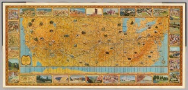
Amfac Resort map of the Coco Palms from the back side of the guest information brochure, July 1981. King's Cottages are located between the lagoon and the coconut grove, to the left of the reception building. Queen's Cottages are to the right

Amfac Resort map of the Coco Palms from back side of guest brochure, circa 1981.

Under Guslander leadership the hotel grew to over 400 rooms across the 32-acre property.

Now the premier resort of Kauaʻi, the Coco Palms could charge a premium for luxury… And it did with some rooms fetching more than $400/night – in 1970s dollars.

The Guslanders sold their interest in the Coco Palms to the Amfac Group in 1969, but they would continue to serve the resort hands-on in a management role.

grace-gus-guslander

Grace & Gus Guslander eventually married in 1969

*

New Ownership & Hurricane Iniki

Coco-51Gus Guslander passed away in 1984 and soon after, Grace retired. Amfac sold their interest in Coco Palms to Wailua Associates in August of the following year.

The new owners were a locally-based real estate development company and had plans to continue Lyle and Grace’s vision for the famed Kauaʻi resort.

However during this time the resort endured a period of stagnation. The economic crisis of the 1970s would drag into the 80s for the cyclically-lagging hotel industry.

Hawaiian hotels were especially slow to recover, and the Coco Palms was no exception. Nevertheless, the lodge continued on offering the same Hawaiian hospitality Grace introduced thirty years prior.

Disaster would strike on September 11th, 1992, when Hurricane Iniki battered Kauaʻi.

The storm was a category-4 hurricane and would be the most powerful to ever hit the state of Hawaii. Winds up to 145 miles-per-hour battered the small island in the Pacific, killing six.

The storm caused an estimated $1.8 billion dollars in damage (estimated $3B in 2014’s dollars) and left residents without power for up to three months. Over 1,400 homes were completely destroyed while another 7,200 were seriously damaged.

Iniki_NOAA

Waves up to 35 feet crashed into the island while storm tides left a high-water mark nearly 18 feet tall.

National attention to the stricken island was unfortunately muted, likely due to Hurricane Andrew weeks prior. Andrew had just leveled South Florida and seemed to exhaust the country’s palate for storm empathy.

Iniki_3 Iniki_2

When Iniki hit Kauaʻi, the 40 year-old Coco Palms was the oldest operating hotel on the island. But due to its age and location on spiritual Hawaiian ground, repairs to the aging resort were always going to be difficult.

Special permits would be required to comply with then-current building codes, and the cultural backlash of building on and modifying holy Hawaiian ground presented its own set of complications.

Making matters worse, there was a post-Iniki recession which befell Kauaian businesses and landed many insurance companies in bankruptcy. As hotel owners fought lengthy claims battles in court with insurance companies, the buildings languished.

Coco-Trespassing-Dennis-Fujimoto Coco-Trespassing-2-Dennis-Fujimoto

photos courtesy Dennis Fujimoto

Sadly the Coco Palms’ matriarch Grace Guslander would never see her historic inn restored; she passed away on April 5th, 2000, at the age of 89.

*

Failed Redevelopment

For the next twenty years the hotel was abandoned, left to its own devices in the fight against Mother Nature. Roadblock after roadblock deterred progress on repairing or re-developing the property.

Ownership groups battled insurance companies and struggled to procure financing for renovations. Local cultural activists continued to lobby against re-development as a nod to the history of the sacred Hawaiian ground.

The Coco Palms property was sold to Coco Palms Ventures LLC in 2006 for a reported $12.3 million. The new owners were a headed by Maryland-based developer Phillip Ross.

Coco-100

The arrangement called for the new owners to invest $220 million into a project which would oversee a massive renovation. Ross’ group drew plans to build 200 condos, 104 hotel rooms, and 48 bungalows across the property. Permits were granted for re-development with a 5-year expiration.

In August of 2006, a sales office had opened and took deposits on the condos with an announced expected date of completion in August of 2008.

By early 2007 Ross admitted his plans required additional investors, and cooperation on the project from Kauai’s Planning Commission – the island’s building permit authority – had become tenuous. The plans had halted and no progress was made.

Depending on whose version of events you believe, the project failed for different reasons.

Coco-98  Coco-97

Ross’ group alleges the planning commission denied permits to build a full-size spa on the property, stalling the project. Members of the commission pointed to Coco Palms Ventures’ inability to locate additional investors in the face of a weakening housing market.

Rumors spread the property was also below the FEMA flood plane, which was preventing developers from being able to procure mandatory insurance coverage. The truth was likely a combination of each.

With no solution in sight, the project was tabled and the property listed for sale.

(click thumbnails to enlarge)

Coco-96 coco-90 Coco-99

coco-92 Coco-93 Coco-94

  photos courtesy Kristin Gregoire

*

Additional Attempts at Redevelopment

When the Coco Palms Ventures bid for redevelopment started to fail, a committee sponsored by the Kauaʻi Public Land Trust was formed in an effort to rescue the dilapidated hotel.

The Friends of Coco Palms was created in 2007 and intended to “preserve the unique natural features and culture of the property” while still making it available for public use. The group wanted to ensure the project was “culturally based and historically respectful.”

Coincidentally the group’s first donor was South Park creator Trey Parker, himself a part-time resident of Kauaʻi. Parker shared,

My parents honeymooned at the Coco Palms hotel and I have watched in disgust as the site remained neglected and abandoned for so many years.

Coco-74 Coco-71 Coco-Lobby-collapse-2012-2

Coco-68 Coco-11 Coco-27-lobby-2012

With start-up money the group could begin community discussions, apply for larger grants, hire professionals to assess the property, and consider re-development possibilities.

Initially the group appeared to make progress – even earning a state grant in the amount of $234,000 – but the financial collapse in 2008 quickly put a halt to that distribution and ended hopes of saving the Coco Palms.

Coco-43 Coco-44

photos courtesy Primo Kimo

*

Another player entered the Coco Palms sweepstakes when Shell Vacations, a North American timeshare operator and owner of nearby Kauaʻi Coast Resort, considered a bid on the abandoned hotel.

However after the timeshare operator performed its due diligence, a spokesperson announced the company had decided against action.

Hope once again turned into despair.

Coco-48

*

Deterioration

By the late 2000′s, the resort had begun to disintegrate rapidly. Decades of vandalism and exposure to the elements had already taken their toll on the structures. A 2009 arson fire heavily damaged the retail annex, the structure which separates the resort from Kuhio Highway.

Despite little visible progress by the developers, the planning commission granted 3-year extensions on the original building permits (which ran through 2010). It was a mild concession in an attempt to give the project life, at least until 2013.

Coco-47 Coco-50 Coco-49

photos courtesy Primo Kimo

In the interim copper thieves, ornament hunters, and vandals have nearly completely stripped the buildings. The giant clamshell sinks have been targets of theft, each leaving a large void on the bathroom counter top adorned by broken tiles.

Any artifact that could remind of vintage Coco Palms Americana or the Blue Hawaii film has been pilfered as a souvenir. Coconut scavengers frequently access the property and collect the fallen fruit.

In February of 2013 thieves broke down hotel walls to make off with four of the resort’s original 8-foot tall doors, weighing 200-300 pounds each and hand-carved from solid Koa wood.

The doors were estimated to be worth about $50k each, but to collectors and fans of the Coco Palms they are priceless.

Coco-aerial-2

Aerial view of the Coco Palms today (view on map)

*

The Future

Coco-Ron-Agor-ArchitectsSince the more recent theft of the doors, optimism has increased as new investors have stepped forward.

In August of 2013 a group of Hawaiian investors breathed life into Coco Palms rumors when they announced plans to purchase the property.

Honolulu-based Tyler Greene and Chad Waters formed Coco Palms Hui LLC with the intent of restoring the classic resort to its pre-Iniki state.

Greene and Waters earned credibility by successfully applying for demolition permits and initiating a clearing of the property (pictured below) – more progress than any group before was able to accomplish on restoring the iconic hotel.

Reconstruction was announced as expected to take between 12-18 months, beginning in 2014.

Coco-04 Coco-05 Coco-03

photos courtesy Reno Craig/Kawakami Builders

Few modifications were proposed, keeping the new resort largely faithful to the original. Aside from the reduction of number of rooms (from 400 to a proposed 350), Greene expected the hotel would look very similar to the pre-Iniki lodge.

Said developer Tyler Greene:

We hope that Coco Palms becomes the true place of aloha that it was prior to Hurricane Iniki, there’s quite a bit to do. It’s a full renovation job. We’ll be peeling the buildings back to the studs, but all the structures that exist today will stay as they are.”

Coco-site-plan-2013

Coco Palms Hui also hopes to renovate the original restaurants and restore the popular lagoon.

It is our hope to have things like weddings and luaus and cultural events there,” said Greene. “We just want it to be a welcoming grounds for residents of Kauaʻi as well as visitors from all around the world.”

*

By September the group was seeking permits. Specifically, they were seeking permits under an old county ordinance which allowed for “a legally nonconforming structure to be reconstructed to its condition prior to Hurricane Iniki.

This was a necessary concession to allow the developers to re-build the resort within a reasonable budget and without significantly altering its appearance.

The ordinance also allows for construction below the flood plane. The property actually sits below the adjacent Kuhio highway, which also serves as a barricade against storm surges.

(click thumbnails to enlarge)

Coco-67 Coco-66 Coco-65

Coco-62 Coco-61 Coco-60

Coco-55

*

Perhaps the best quote regarding the hotel’s current situation came from author David Penhallow, good friend of Grace Guslander and author of the book The Story of Coco Palms Hotel.

Recounts David:

“The Coco Palms wasn’t a place. It was a time, and that time is over.”

Great observation. The Coco Palms was a serendipitous confluence of circumstances, driven by a dynamic woman. When the hotel is rebuilt it will not have Grace Guslander, and she is what made the Coco Palms special.

coco_palms_lagoon_dining coco_palms_lagoon_dining_flood_1955 Coco_Palms_Queens_Cottages

Coco-08_Lagoon Coco-25-lobby-inside Coco-28-coconut-palace

courtesy David Penhallow

*

Did You Know?

• You can tour the Coco Palms. Bob Jasper runs Coco Palms Tours & Tees, which offers a Monday-thru-Friday tour of the site. For more information visit his website.

• You can still get married (or renew your vows) at the Coco Palms. Local legend, original employee, and resident caretaker Larry Riviera offers Blue Hawaii Weddings. For a lagoon ceremony, send Larry an email: LarryRiviera@hawaiian.net. (Here’s a Wall Street Journal review of his wedding services)

• Hurricane Iniki whacked the insurance industry for nearly $3 billion, which led to a mass retreat by the coverage providers. After Iniki, insurance companies stopped writing and renewing policies in Hawaii.

hurricane-strapThe state was forced to create the Hawaii Hurricane Relief Fund, a government-run insurance program launched to keep Hawaii’s post-Iniki real estate industry solvent. Insurance companies later returned to the islands in 2000 and the program was suspended in 2002.

• The storm forced Kauaʻi to adopt tougher building codes. Among the changes: Wood-framed walls must now be reinforced at the roof and foundation with hurricane straps. (pictured at right)

• The first time the name “Iniki” appeared on the United States Social Security Administration’s Baby Names Registry was 1992. That year 35 newborns (28 girls, 7 boys) in the United States were named “Iniki.”

• Kauaʻi had long been a home to underground cock-fighting. Hurricane Iniki blew apart many chicken coops, releasing the chickens and roosters on the island. With no mongooses or other natural predators to hunt them or eat their eggs, the chicken population has exploded.

Visitors can find wild chickens and roosters across the island, descendants of those freed by Iniki over 20 years ago.

kauai-roosters-chickens

• Stephen Spielberg and 130 members of his cast and crew were in Kauaʻi filming Jurassic Park when Hurricane Iniki struck. The team was fortunately able to seek safe refuge in a hotel.

• A 2012 South Park episode “Going Native” featured the Coco Palms. (creator Trey Parker is a part-time resident of Kauaʻi and booster of prior Coco Palms preservation efforts)

Coco-30-SP1 Coco-31-SP2

• Notice an absence of tikis around the Coco Palms? According to friends of Grace Guslander, she did not feature them out of respect to the Hawaiian culture and sacred grounds on which the hotel was built.

• The centuries-old fish pond on the property was added to the National Register of Historic Places in 2009. (Believe or not, this was one of the conditions to the developer for a permit extension by the council.)

*

Coco-59 Coco-57 Coco-73

Coco-86 Coco-83 Coco-70

Coco-82

thanks to coco-palms.com, David Penhallow, Larry Riviera, and our partner photographers

*

Coco-28-guest-folder Coco-29-napkin Coco-50-matches

Coco-Palms-brochure-1960 Coco-Palms-brochure-1960-2

original Coco Palms guest book, napkin, match book, and menu/program

**


Viewing all 97 articles
Browse latest View live